|
| |||
| Pacifica Island | |||
| |||
| Motto National Motto: "Urbs in Mare" - City in the Sea | |||
| National Anthem National Anthem: "Never Gonna Give You Up" - Rick Astley | |||
| Capital City | National City | ||
|---|---|---|---|
| Official Language(s) | English | ||
| Established | 02/26/2007 (6,262 days old) | ||
| Government Type | |||
| Alliance | The Centurion Brotherhood | ||
| Nation Team | |||
| Statistics as of 06/10/2008 | |||
| Total population | 136187 | ||
| 96187 civilians | |||
| 40000 soldiers | |||
| Literacy Rate | 100% | ||
| Religion | |||
| Currency | |||
| Infrastructure | 9090.00 | ||
| Technology | 2414.74 | ||
| Nation Strength | 57348.704 | ||
| Nation Rank | 1507 of 5,242 (28.75%) | ||
| Total Area | 3051.961 | ||
| Native Resources | Iron, Lumber | ||
| Connected Resources | Aluminum Cattle Fish Iron Lumber Marble Pigs Spices Sugar Water Wheat Uranium | ||
| Bonus Resources | Beer Construction Fast Food | ||
Nation Information[]
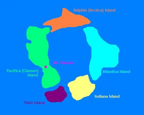
The Territory of Pacifica, more commonly known simply as Pacifica Island, is a country in the Pacific Ocean located roughly 800 miles west-southwest of Honolulu, Hawai'i. The country itself consists of five islands in an archipelago: Pacifica Island (the largest, and therefore namesake island), Dolphin Island, Atlantica Island, Indiana Island, and Palm Island.
The nation is operated as a city-state through its largest city, National City, making the Mayor of National City head of state for the entire nation. National City is located on northern Pacifica Island, near and around Northern Inlet. The city spans from the west coast of the island to the east coast, along Independence Lagoon.
The Territory of Pacifica/Oceana Archipelago (Current)[]
Pacifica Island[]
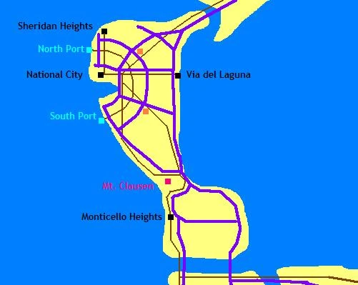
Brown lines are Sheridan Railroad lines; purple lines are current superhighways. Light blue squares are ports; orange squares are airports.
History[]
Pre-Discovery[]
The five islands of Pacifica were originally a large atoll consisting of a much smaller Pacifica Island and reefs circling the eastern shore of the island, forming a shallow lagoon roughly thirty miles wide. The islands were uninhabited, save for several indigenous bird species. Pacifica Island itself was formed by volcanic action as the Pacific Plate passed over a lava fissure, creating a large volcano. As the years progressed, the volcano slowly eroded to the east, forming the large shallow lagoon and reefs. The remainder of the volcano is today's Mt. Clausen, standing a mere 312 ft above sea level.
Discovery, Settlement, and Abandonment[]
In 1855, Adm. Ryan Clausen spotted the mountain since named for him while sailing from California to Australia after stopping in Hawai'i. Finding the island rich with guano deposits, like many other Pacific islands, he declared the country American soil and set up a guano extraction operation. He also named the island and the mountain after himself.
By 1859, the island's small guano deposits had been exhausted and the island was abandoned.
The Civil War[]
In 1861, the United States found itself in domestic turmoil as the Confederacy seceded from the Union. After several successful Confederate battles, the Union government secretly worried about the consequences of a Confederate capture of Washington, D.C. With the sacking of D.C. during the War of 1812 only one generation prior, President Lincoln secretly commissioned the construction of an alternate capital city as far away from the battles as possible—selecting Clausen Island as the new site for the city.
Lincoln selected a group of settlers from his home states of Kentucky, Indiana, and Illinois to settle the island and set up a permanent city. The settlers sailed from San Francisco Bay on April 3, 1863 and arrived at Clausen Island on April 27, 1863.
Unknown to the civilized world, a hurricane sometime between 1859 and 1863 struck Clausen Island directly. The eye made landfall several miles north of Mt. Clausen and eroded much of the sandy soils. What resulted was a deep, natural inlet, which the settlers named Northern Inlet, due to its location relative to the island. The site for the city was chosen to be immediately north of Northern Inlet for its uses as a harbor.
The low, flat elevation of the northern part of the island was perfect for the grid-style development patterns that the settlers from Illinois and Indiana were used to in their home states. Several blocks were constructed and given names similar to streets in Chicago, Illinois, the home city of many settlers. The city was named Union City, as it was meant to be the new Union capital.
The city had barely been established when the Civil War ended in 1865. A hurricane in 1868 destroyed the city, and the remaining settlers abandoned the island once again.
Turn of the 20th Century[]
In the 1870s, the Hawaiian Islands nearby plunged into instability due to elections for the next monarch of the Kingdom of Hawaii. In 1874, British and American forces were sent to Hawaii to quell riots due to an allegedly fraudulent election by the legislature.
In the 1870s and the 1880s, as more Americans became involved in Hawaiian commerce, the U.S. government began considering opening a naval base in the Pacific to protect "American interests" in the region. Several islands in the area were considered for military bases, including Midway Island, Pearl Harbor, and Clausen Island.
Clausen Island was chosen for a military base and, in 1883, Naval forces were sent to the island to begin surveying the island and its environs for suitable base locations. The naval report concluded that Clausen Island would be too small to suitably house a base; however, coral and lagoon dredging could expand the island to a large enough size to sustain a military presence. Construction on Clausen Island expansion began in 1886.
The next year, the U.S. Navy began leasing Pearl Harbor as a naval base from the Hawaiian monarchy. (In 1894, the U.S. government overthrew the Hawaiian monarchy and established a Provisional Government. By 1898, Hawaii was officially an American territory.)
Despite Pearl Harbor's opening, construction on Clausen Island quietly continued, expanding the island south of Mt. Clausen. Union City was resettled in 1887 for workers on the project; however, the city was settled this time under the name National City. A second city, Monticello Heights, was settled on the west coast of southern Clausen Island, mainly to be a port for construction materials dealing with the south Clausen Island expansion project. With most of the work going on south of Mt. Clausen and National City being situated on Northern Inlet, a small narrow-grade railway was built between National City and Monticello Heights by real-estate magnate William Sheridan. Sheridan officially built the railroad at narrow-gauge due to the difficulties of going around Mt. Clausen; however, the real reason was so rail cars could not be imported, but rather built on-site—in Sheridan's own shops.
Sheridan built a community exclusively for his company and employees about 10 miles north of downtown National City, named Sheridan Heights. (Sheridan found the irony of naming Monticello Heights as such, due to the island's low elevations, that he decided to add "Heights" to his community as well.) Sheridan constructed a large central depot near downtown National City. The line ran east, then turned due south to pass Northern Inlet. The line continued south to the foothills of Mt. Clausen, where it turned east and wrapped around the northeast and southeast corners of Mt. Clausen. The line then went west to the shore, and headed south to Monticello Heights.
By the end of the Spanish-American War, the U.S. government decided that a military presence in the Pacific was necessary for national defense. The Clausen Island base, however, continued to be a silent, if not secret, operation. Following the Spanish-American War, plans for the Clausen Island military base were greatly expanded. Coral and lagoon dredging was to continue on a much grander scale—constructing three entirely new islands east of Clausen Island. Clausen Island would remain mostly civilian; the eastern island would have the heaviest military presence; the northern and southern islands would be "garden islands" to grow small crops to help sustain the expectedly-increased populations of the new archipelago.
Secrecy Begins[]
In 1903, the U.S. federal government sent out a release saying that Clausen Island was entirely wiped out by a hurricane, and that Clausen Island should not be included on any future maps for public use. Official government maps of the area showed the entire Clausen Island area as dangerous shallow reefs and warning vessels to stay away.
The Navy nicknamed the Clausen Island dredging operations as "Operation Oceana." As such, the four islands in the new archipelago would each be named after the four great oceans of the Earth: Pacifica Island on the west (Clausen Island), Indiana Island on the south, Atlantica Island on the east, and Arctica Island on the north. To maintain a sense of history, however, Mt. Clausen was to keep its name. Pacifica Island was to be the civilian and governmental island, with National City serving as Operation Oceana's "capital". Arctica and Indiana Islands were to be the farm islands; Atlantica would serve as the military base.
The islands were fully dredged and formed by 1915, about the time the first automobiles began driving on National City streets. In 1919, National City Mayor Elias Irving commissioned the creation of a plan for the growth of National City and the surrounding environs. This commission became the North Pacifica Plan Commission, responsible for the growth of National City and all of Pacifica Island north of Mt. Clausen.
The National City Plan[]
By the time the plan commission returned with their final plans in 1921, the demographics of north Pacifica Island had changed greatly. Sheridan's empire grew with the construction of a new railway southeast out of downtown, connecting with the existing mainline near Mt. Clausen. As such, southern and southeastern National City were populated with mostly working-class citizens; northern National City became the domain of the more affluent, especially around Sheridan Heights, which was broadened from an exclusive company town to a bedroom community for many of National City's workers. Much of Pacifica Island south of Monticello Heights, especially along the coasts, became tourist oriented for short holidays of National City's more affluent populations to escape the city for a few days. The southern shore of Pacifica Island became known as Palm Shores, due to the shallow beaches and palm trees planted to help fight erosion of the newly-build island. The village of Palm Shores Plantations was incorporated in 1907, and by 1912 the Sheridan Railroad built a spur south from Monticello Heights to Palm Shores.
The 1921 Plan for Pacifica had two scopes: exclusively on National City, and the Oceana Archipelago as a whole.
National City[]
One of the main problems with downtown National City was congestion—the city was at the nexus point of Northern Inlet, dealing with industrial freight in Northern Inlet, commerce for the citizens of the City, and residents both commuting to and through downtown. Southbound roads and highways around Northern Inlet became a pinch-point in the system, forming long delays during rush hours.
The plan commission had several recommendations for downtown National City. Downtown was officially divided into quadrants by two streets: Central Avenue (formerly 8th Street) running east-west, and Downtown Highway (formerly Clark Street) running north-south. The four-block area where the two streets met would be cleared and a circular roadway, the Circle of Progress, would be constructed. Two diagonal streets would cut through the heart of the Circle, one running northeast-southwest (Northeast Highway) and one running northwest-southeast (Franklin Avenue). The streets would form an X in an otherwise-regular grid of + intersections, forming a visual center of National City. The City Hall and Courthouse would be constructed facing each other in the Circle of Progress and this area would be known as the City Centre.
(A picture of the plan for City Centre was printed on the cover of each copy of the report. This picture was later colorized and became the official National City seal in 1935.)
Franklin Avenue would connect with a new multi-lane highway to be constructed near the western shore north of National City (Sheridan Highway), cut through City Centre, and cross over the eastern tip of Northern Inlet on a new bridge. Franklin would then continue southeastern.
Northeast Highway would start in the southwest corner of downtown National City and continue northeast indefinitely; likewise, Central Avenue would be extended east to Pacifica Island's lagoon shoreline. The Plan Commission also recommended spur lines of the Sheridan Railroad in similar trajectories. (The North, Southeast, and South spokes of the Sheridan system were already in place.)
The largest change the Plan Commission recommended was the formation of two new ports: North Port and South Port, both to be located about 5 miles north and south (respectively) of Downtown. The two would be connected by a beltway railroad that ran roughly at a 5 mile radius outside of downtown. North Port was to be built first, to replace the current Northern Inlet ports; South Port was to be constructed at a later date. Along the beltway, industrial companies would be encouraged to relocate and build, removing them from downtown and allowing easier freight trips to port.
The Plan also called for the allocation of land for two airfields, one northeast and one southeast of downtown, both of which to lie near the Industrial Belt.
Plan for Oceana[]
The largest plan for Oceana called for a belt transitway to connect all four islands, consisting of a highway and a railway. On Pacifica Island, the beltway would split into a West Beltway to run along the west coast of the island from Mt. Clausen to north of National City, and the East Beltway to run along the east coast of the island, along the lagoon.
The Plan Commission also recommended implementing a trans-lagoon ferry service to assist in inter-island commutes. A community serving as a ferry port was designed at the eastern end of Central Avenue/the eastern spur of the Sheridan Railroad, aptly called "Via del Laguna." Each island would have at least one ferry terminal, and lagoon marine traffic would be limited to ferries and recreational craft (due to the shallow depths).
Plan Reception[]
The plan was very widely received by both the citizens of Pacifica and the federal government, which gladly implemented many of the recommendations of the plan.
The plan was officially ratified March 12, 1923, and its implementation was widely believed to be a key reason the effects of the Great Depression were muted on the archipelago during the early- and mid-1930s.
Atlantica Island Military Base[]
Atlantica's Military Base "officially" opened January 14, 1920. (To this day, the U.S. government has not officially acknowledged any military involvement at Atlantica Island.) The base was mainly a naval base, but an airfield with experimental aircraft was also constructed on Atlantica. The Atlantica base was home of the U.S.'s first experimental jet aircraft in the Pacific. The base was the primary employer of Pacifica's residents from 1920 through World War II.
The hurricane and Summit of 1936[]
On August 4, 1936, a large hurricane hit the Oceana Archipelago, serving as the first main test of the new islands and the Navy's coral dredging methods.
The hurricane hit Oceana hard. National City and north Pacifica escaped with some property damage and Atlantica Island had nominal damage to base buildings. The hurricane, however, greatly changed the landscape of the islands.
Arctica Island's northwestern shore eroded into the ocean, leaving a large crater-looking coastline in Arctica's northwest. The hurricane eroded a large passage through south Pacifica Island, separating Palm Shores from the rest of Pacifica Island, and nearly leveling Palm Shores Plantations.
The Oceana government met in National City on August 10, 1936 to discuss the effects of the hurricane and how the archipelago would recover. Community and government leaders throughout the archipelago were encouraged to attend. What resulted was the Summit of 1936, a 3-day affair that completely reformed Oceana forever.
First and foremost, the representatives from the Palm Shores insisted that the new canal remain and that they should be recognized as a fifth island in the archipelago, Palm Island. The canal, they said, would allow Palm Shores/Island to flourish as a tourist destination.
Once this was granted, the citizens of Arctica Island requested an official name change. Citing issues of tourism competition within the archipelago (Palm Island sounds like a much nicer place to vacation than Arctica Island), Arctica's representatives recommended changing the name to Dolphin Island, as the island's shoreline now indeed resembled a dolphin following the massive erosion on the northwestern shore. This was also granted.
The Summit also provided for several autonomous steps for the local government. The archipelago was now to be known as the Territory of Pacifica, named for Pacifica Island. A territory flag was also created, the same flag that flies over the archipelago today.
World War II[]
Due to the base's extreme secrecy, the Japanese ended up bombing Pearl Harbor instead of Atlantica. (Several conspiracy theorists claim that the Americans had advance knowledge of the attacks because none of the aircraft carriers were in Pearl Harbor that Sunday, when they normally are. The official Navy stance is that the carriers were performing operations at sea, but they were actually in dock at Atlantica.) There are also unconfirmed rumors that the Battle of Midway occured because the Americans felt the Japanese were too close to discovering Pacifica's location and thus lured them to Midway instead. Either way, Atlantica Island served a crucial function during World War II, refueling American ships and planes and ensuring the protection and safety of supply lines out into the Pacific theater. The population of the islands flourished throughout the war as more soldiers were stationed there and more made Pacifica their homes after being discharged.
Post-War[]
With the burgeoning population of Pacifica following WWII paralleling the population growth back on the American homefront, the federal government chose Pacifica Island as the ideal testing ground for a new superhighway project, in particular superhighways in urban settings.
Four initial superhighways were constructed in National City: the North Superhighway (heading north to Sheridan Heights, basically upgrading Sheridan Highway), the Central Superhighway (paralleling Central Avenue from downtown to Via del Laguna), the Southwest Superhighway (downtown to National City Airport), and the South Superhighway (wrapping around the southern shore of Northern Inlet, then heading south along the coast). Later, a fifth highway was constructed from Downtown to the site of the proposed North Airport. A belt highway near the Industrial Belt was also built to connect all the superhighways.
The results were disastrous. The highways cut access to areas of the city that made neighborhoods flourish. The North Superhighway, for instance, cut the city off from the northern beaches and oceanfront parks. The Central Superhighway paralleled the five-track Sheridan Railroad line, forming a two-block-wide virtual barricade through the east side of the city. The South Superhighway performed the most damage, cutting off the Wilson Park neighborhood from the remaining industries along Northern Inlet. People began abandoning the city in droves for the rapidly growing suburbs. As opposed to cities like Chicago and Detroit, there was no black exodus to fill the dwindling city population. Rather, the city slowly began to abandon itself.
The Depression[]
The 1973 oil crisis had disastrous results for a society that required on entirely imported oil, such as Pacifica. As such, in 1974 the U.S. decided to close the Atlantica military base, citing rising fuel and maintenance prices for offshore bases. The closure of the base was disastrous to the Pacifica economy, combined with the National City exodus. Due to the dwindling populations, industries stopped moving to National City and Pacifica; the South Port of the 1921 plan was never completed, nor was the North Airport. Despite the base's closing, however, the U.S. government still regarded the Territory of Pacifica as secret, and thus tourism (other than inter-island) was strictly prohibited, stifling a potentially large source of income for Pacifica businesses.
By 1980, the military base had been closed and destroyed. The non-developed areas of Atlantica Island and the former base were designated as a wildlife refuge by the U.S. Department of the Interior.
The Pacifica Renaissance[]
The Territory of Pacifica, namely National City, remained the test site for many government projects that were too secret to publicly announce. By the 1980s and 1990s, however, successful test after successful test revitalized National City and the Territory.
Pacifica was one of the first testing grounds for satellite and cellular phones in the 1980s; the Territory was also the test site for many computer- and Internet-related public tests, including the first public wireless system test in the late 1990s.
These technological advances attracted the attention of numerous technology industries, and National City's economy once again flourished. This was, for all intents and purposes, the first infusion of "smart" industries in National City; as such, high culture began moving south from the high-class Sheridan Heights suburbs to the streets of National City. Neighborhoods began revitalizing themselves as "artist enclaves" with loft apartments and gallery spaces in formerly industrial areas, most notably the East Inlet area near Sheridan Central Station. The University of National City took the opportunity to purchase a few square miles of abandoned neighborhood just northeast of downtown and construct a full campus, opening for its 25,000 students in 1999. The neighborhood for blocks and blocks around instantly turned around, offering affordable student housing and amenities so close to the heart of downtown.
The Current Mayor[]
In 2002, the current Mayor of National City was elected. Focusing on neighborhood redevelopment and "greening" the city, the Mayor made Northern Inlet his priority. He removed most of the industrial buildings south of 1st Street and created Inletside, a waterside park now in the heart of downtown. The former ports on the south side of Northern Inlet (still cut off from Wilson Park by the South Expressway) were also removed and the space cleared for public use.
2004 saw the opening of the Stephen Drennen Memorial Bridge, a massive suspension bridge over the mouth of Northern Inlet, providing a direct link from downtown (via Northeast Highway) to Wilson Park on the other side of the Inlet. The Drennen bridge revitalized the Wilson Park neighborhood, providing a close tie with Downtown while also providing a trademark silhouette on the National City skyline.
Re-elected in 2006, the Mayor presided over the handover of power in February 2007.
Current Pacifica Island / CN Play[]
On February 26, 2007, the U.S. government officially (and still very quietly) granted the Territory of Pacifica its independence from the United States. Even today, aerial imagery of Pacifica Island on public servers (such as MSN or Google) shows the fictional Johnston Atoll at the location of Pacifica Island.
The nation is operated as a city-state, with the Mayor of National City serving as the director of the national government as well.
Since Pacifica Independence Day, the achievements of the citizens of Pacifica have been detailed by the online game CyberNations.
The Centurion Brotherhood[]
In the summer of 2007, the U.S. government announced that Pacifica would no longer be an official protectorate. As such, Pacifica Island joined the Centurion Defense Cell (CDC) in late summer 2007. In October 2007, the CDC merged with The Centurion Brotherhood, which Pacifica Island has been a proud member of ever since. The Mayor also serves as the alliance Director of Commerce (Trade).
Domestic Achievements[]
Since Pacifica Independence, Pacifica Island has made the following improvements:
- New banking centers in National City, Sheridan Heights, Monticello Heights, Via del Laguna, and Palm Shores Plantations;
- A complete five-phase Border Defense program;
- A state church on each island;
- The Pacifica Health Care System with local clinics in National City, Sheridan Heights, Monticello Heights, Via del Laguna, and Palm Shores Plantations, as well as a teaching Hospital incorporated with the University of National City;
- All five Phases of the Industrial Belt completed;
- Construction of an Embassy Row in National City, allowing for foreign ministries in Pacifica Island;
- Completion of South Port, a new Pacifica Island harbor;
- A National Intelligence Agency network with 5 bureau offices;
- Five work camp programs in conjuncton with the Pacifica Bureau of Corrections;
- Police Bureaus in each of the 5 islands;
- School districts in National City, Sheridan Heights, Monticello Heights, Via del Laguna, and Palm Shores Plantations;
- Five stadiums in the InletSouth recreation complex; and
- the University of National City and the Pacifica State University.
Pacifica Island has also proudly implemented the following National Wonders:
- The Great Monument to Capitalism;
- The People's Temple;
- Disaster Relief Agency;
- National internet infrastructure;
- Department of Defense Headquarters;
- Limited-access high-speed freeway system connecting the five islands;
- Development of a National Research Lab in conjunction with PacState; and
- Government-sponsored retirement package (Social Security).
Pacifica Island is pushing forward with its Rural Modernization Act (Agricultural Development Program), scheduled for completion in mid-February.
Military[]
Pacifica Island's defense forces are largely the Territory Police, who monitor and serve for both domestic disputes and international conflicts. The Territory Police keep a central armory in eastern National City with a tank division numbering roughly 4000 armored units, and keeps a fleet of 85 planes at North Airport.
Since summer of 2008, Pacifica Island has made a significant investment on land, air, and sea.
Aerial Defense[]
Pacifica Island keeps no less than 20 cruise missiles on hand at any given time in case of armed conflict. In the interest of defense, Pacifica Island has developed five missile defense stations to reduce the effectiveness of a missile attack on the Islands.
Nautical Defense[]
The Pacifica Navy is quickly becoming the pride of the Central Pacific. As of October 2008, the fleet consists of 59 vessels including aircraft carriers capable of incresing the capabilities Pacifica Air Force substantially. Pacifica Island is single-handedly responsible for 8% of the alliance's naval forces. Pacifica Island currently has five shipyards and five drydocks.
Both the University of National City and Pacifica State University have started naval ROTC programs to improve the potency of our seamen.
Karma War[]
On April 23, 2009, as part of the alliance offensive against Invicta, Pacifica Island declared war on Anarcasia. In retaliation, the nation of Llonach declared war on Pacifica Island.
At 9:46:31pm server time, the nation of Llonach detonated the first-ever nuclear weapon over Pacifica Island, with the expected massive losses. Having developed a Manhattan Project just a week before, Pacifica Island retaliated with a nuclear attack on Llonach, obliterating all ground forces.
After heavy losses on both fronts, a ceasefire agreement was reached alliance-wide in early May, 2009. While infrastructure, technology and land levels remain far below pre-war levels, the growth of Pacifica Island's nuclear arsenal has allowed NS to quickly recover to pre-war levels.
Official Imagery[]
The adoption of official flags for both the Territory of Pacifica and the City of National City was settled at the Summit of 1936. The City Seal of National City was approved a year earlier, in 1935.
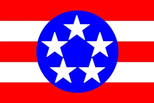
Territory Flag[]
The Territory flag consists of five five-point white stars in a blue circle on a field of three red stripes and two white stripes. The white stars on a blue field scheme as well as the red and white stripe scheme signify the Territory's administration by the United States for so many years. The five stars, five-pointed stars, and five stripes all represent the five islands of the Territory, while the blue circle represents the unity of the five islands.
Residents point to the "invisible" blue pentagon formed by the interior angles of the five stars as a tongue-in-cheek reference to the Territory's supposed invisibility to the Pentagon, referring to the U.S. Department of Defense's headquarters and the U.S.'s official stance disavowing all knowledge of the Territory of Pacifica. However, the flag was adopted six years before the Pentagon was built.
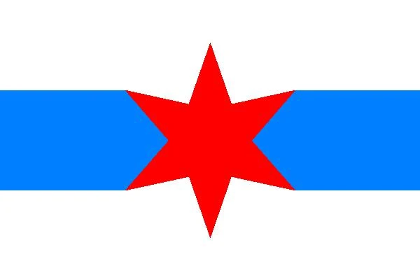
City Flag[]
The City Flag of National City consists of a red six-pointed star located in between two blue irregular pentagons on a white field. The star represents National City and its location relative to Northern Inlet (the left band) and Independence Lagoon (the right band), as the city spans the width of the island between these two bodies of water.
The flag also pays homage to the city's Chicago roots in the color scheme, inclusion of water elements, and the red six-pointed star, all of which are included in the City of Chicago's flag.

City Seal[]
The city seal was inadvertently created in 1921 by the plan the Plan Commission released. To illustrate the street layout of the new City Centre (as well as due to its symmetrical and simple design), a small diagram of the street layout of City Centre was printed on the cover of the 1921 plan. The diagram was later colorized and was voted to be the new City Seal by the city council in 1935.